
Rajasthan- Relief and Structure
The main geographic feature of Rajasthan is the Aravalli Range, which runs across the state from southwest Guru Peak (Mount Abu), which is 1,722 m in height to Khetri in the northeast, for more than 850 km. This divides Rajasthan into 60% in the North West of the lines and 40% in the southeast. The northwest tract is sandy and unproductive with little water but improves gradually from desert land in the far west and northwest to comparatively fertile and habitable land towards the east of India. The area includes the Great Indian (Thar) Desert. Mount Abu is at the southwestern end of the range, separated from the main ranges by the West Banas River, although a series of broken ridges continues into Haryana in the direction of Delhi where it can be seen as outcrops in the form of the Raisina Hill and the ridges farther north of India. About three-fifths of Rajasthan lies northwest of the Aravallis, leaving two-fifths on the east and south of India.
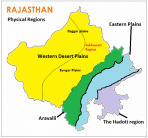
On the basis of the existing relief features, Rajasthan has been divided into the following physiographic divisions:
- Western Sandy Plains :
The surface of western Rajasthan is covered with vast stretches of sand occasionally interrupted by rocky protruding right up to the Pakistan border.
(a) Sandy Arid Plains
(i) Marusthali
(ii) Dune free Tract
(b) Semi-Arid Transitional Plains (Rajasthan Bagar)
(i) Luni Basin (Godwar Tract)
(ii) Plain of Interior Drainage (Sekhawati Tract)
(iii) Ghaggar Plain
63 per cent sand dune area of Rajasthan is concentrated in the desert districts of Barmer, Jaisalmer and Bikaner.
- Aravalli Range And Hilly Region
The principal and most dominant mountain range of Rajasthan is the Aravalli range. The geological history of the Aravalli range can be traced back probably close of the dharwar times. This range runs diagonally across the State from northeast near Delhi and extends to southwest up to the Plains of Gujarat, for a distance of about 692 kilometers
- Aravalli Range and Bhorat Plateau
This division constitutes east Sirohi, nearly the whole of Udaipur except a narrow belt in the east and whole of Durgarpur district. The highest section of the Aravalli range known as ‘Bhorat’ Plateau lies northwest of Udaipur between Kumbhalgarh – Gogunda and the average elevation of this plateau is 1,225 metres.
- Northeastern Hilly Region
Northern edge of Bhorat Plateau marks the boundary of north eastern hilly tract in the southwest. North of Kumbhalgarh, especially at the Alwar hills the elevation varies between 550 m to 670 m.
- Eastern Plains
The area on the northeast, east and southeast of the Aravalli range is known as the Eastern Plain. The Vindhyan Plateau marks the southeastern
288 448s170.8 0 213.4-11.5c23.5-6.3 42-24.2 48.3-47.8 11.4-42.9 11.4-132.3 11.4-132.3s0-89.4-11.4-132.3zm-317.5 213.5V175.2l142.7 81.2-142.7 81.2z"/> Subscribe on YouTube